Datoteka:1794 Anville Map of the Ancient World - Geographicus - AncientWorld-anville-1794.jpg

Veličina ovog prikaza: 800 × 579 piksela. Ostale razlučivosti: 320 × 232 piksela | 640 × 463 piksela | 1.024 × 741 piksela | 1.280 × 926 piksela | 2.560 × 1.852 piksela | 5.000 × 3.618 piksela.
Vidi sliku u punoj veličini (5.000 × 3.618 piksela, veličina datoteke: 4,69 MB, MIME tip: image/jpeg)
| Ova je datoteka sa Zajedničkog poslužitelja i mogu je rabiti drugi projekti. Opis s njezine stranice s opisom datoteke prikazan je ispod. |
| Jean Baptiste Bourguignon d'Anville: Orbis Veteribus Notus.
( |
|||||||||||||||||||||
|---|---|---|---|---|---|---|---|---|---|---|---|---|---|---|---|---|---|---|---|---|---|
| Umjetnik/stvaratelj |
|
||||||||||||||||||||
| Naziv |
Orbis Veteribus Notus. |
||||||||||||||||||||
| Opis |
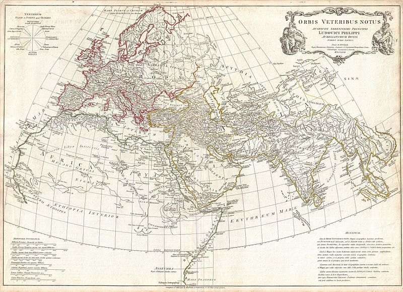
English: A large and dramatic composite 1794 map of the world as it was known to the ancients, by J. B. B. D'Anville. Covers all of Europe, Asia Minor, Arabia and India, much of Northern Africa, and parts of Southeast Asia. D'Anville compiled this map from various sources including Ptolemy, Herodotus, Thucydides, and others. In Africa, the author notes various cities from Ptolemy's Geographica , including Rapta, Axum, Garama, and others. Includes the Mountains of the Moon, Lakes of the Nile, and other conjectural destinations. Far in the south a note reads, Aethiopes Anthropophagi, which essentially translates to African Cannibals. In the Far East a number of classical locals are noted, including the island of Taprobana (Celon) and the empires of Southeast Asia. Details mountains, rivers, cities, roadways, and lakes with political divisions highlighted in outline color. Title cartouche appears in a baroque frame in the upper left quadrant. Cartouche is flanked on either side by malignant appearing figure with a telescope and a studious scholar reading a book. Includes eight distance scales, bottom left, referencing various measurement systems common in antiquity. Text in Latin and English. Drawn by J. B. B. D'Anville in 1762 and published in 1794 by Laurie and Whittle, London. |
||||||||||||||||||||
| Datum | dated 1763, published 1794 | ||||||||||||||||||||
| Dimenzije | visina: 21 in (53,3 cm); Širina: 30 in (76,2 cm) | ||||||||||||||||||||
| Inventarni broj |
Geographicus link: AncientWorld-anville-1794 |
||||||||||||||||||||
| Izvor/fotograf |
D'Anville, J. B. B., Complete Body of Ancient Geography, Laurie and Whittle, London, 1795.
|
||||||||||||||||||||
| Dopuštenje (Naknadna uporaba ove datoteke) |
|
||||||||||||||||||||

Povijest datoteke
Kliknite na datum/vrijeme kako biste vidjeli datoteku kakva je tada bila.
| Datum/Vrijeme | Minijatura | Dimenzije | Suradnik | Komentar | |
|---|---|---|---|---|---|
| sadašnja | 16:35, 23. ožujka 2011. | | 5.000 × 3.618 (4,69 MB) | BotMultichillT | {{subst:User:Multichill/Geographicus |link=http://www.geographicus.com/P/AntiqueMap/AncientWorld-anville-1794 |product_name=1794 Anville Map of the Ancient World |map_title=Orbis Vetribus Notus. |description=A large and dramatic composite 1794 map of the |
Uporaba datoteke
Na ovu sliku vode poveznice sa sljedećih stranica:
Globalna uporaba datoteke
Sljedeći wikiji rabe ovu datoteku:
- Uporaba na fa.wikipedia.org
- Uporaba na fa.wikibooks.org
- Uporaba na ja.wikipedia.org
- Uporaba na pt.wikipedia.org
- Uporaba na ru.wikipedia.org
- Uporaba na sh.wikipedia.org
- Uporaba na tr.wikipedia.org