Datoteka:1801 Cary Map of Persia ( Iran, Iraq, Afghanistan ) - Geographicus - Persia-cary-1801.jpg
Veličina ovog prikaza: 669 × 600 piksela. Ostale razlučivosti: 268 × 240 piksela | 535 × 480 piksela | 856 × 768 piksela | 1.142 × 1.024 piksela | 2.284 × 2.048 piksela | 5.000 × 4.484 piksela.
Vidi sliku u punoj veličini (5.000 × 4.484 piksela, veličina datoteke: 6,9 MB, MIME tip: image/jpeg)
| Ova je datoteka sa Zajedničkog poslužitelja i mogu je rabiti drugi projekti. Opis s njezine stranice s opisom datoteke prikazan je ispod. |
_-_Geographicus_-_Persia-cary-1801.jpg)
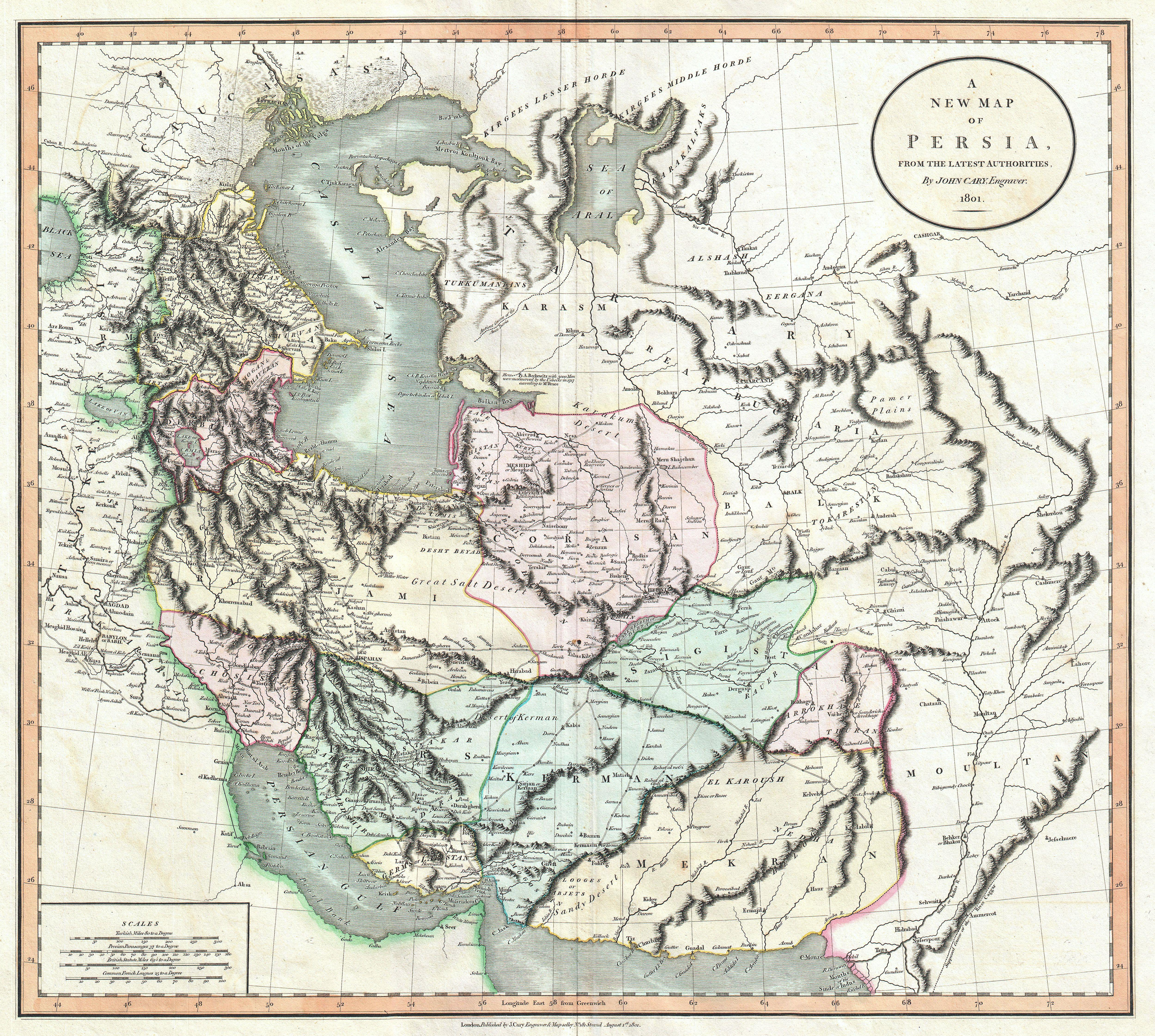
| John Cary: A New Map of Persia, from the Latest Authorities.
( |
||||||||||||||||||||||||||
|---|---|---|---|---|---|---|---|---|---|---|---|---|---|---|---|---|---|---|---|---|---|---|---|---|---|---|
| Umjetnik/stvaratelj |
|
|||||||||||||||||||||||||
| Naziv |
A New Map of Persia, from the Latest Authorities. |
|||||||||||||||||||||||||
| Opis |
English: An exceptional example of John Cary’s important 1801 map of Persia. Extending from the Black Sea coast eastward as far as Kabul and southward as far south as the Persian Gulf, this map encompasses modern day Iraq, Iran, and Afghanistan, the seat of the current hostilities in the Middle East. Offers extraordinary detail regarding cities, trade routes and physical geography. In some cases Cary offers annotations on important battle sites and on the ruins of ancient Mesopotamian cities. All in all, one of the most interesting and attractive atlas maps of Persia to appear in first years of the 19th century. Prepared in 1801 by John Cary for issue in his magnificent 1808 New Universal Atlas . |
|||||||||||||||||||||||||
| Datum | 1801 (dated) | |||||||||||||||||||||||||
| Dimenzije | visina: 18,2 in (46,3 cm); Širina: 21,5 in (54,6 cm) | |||||||||||||||||||||||||
| Inventarni broj |
Geographicus link: Persia-cary-1801 |
|||||||||||||||||||||||||
| Izvor/fotograf |
Cary, John, Cary's New Universal Atlas, containing distinct maps of all the principal states and kingdoms throughout the World. From the latest and best authorities extant. London: Printed for J. Cary, Engraver and Map-seller, No. 181, near Norfolk Street, Strand, 1808.
|
|||||||||||||||||||||||||
| Dopuštenje (Naknadna uporaba ove datoteke) |
|
|||||||||||||||||||||||||
Povijest datoteke
Kliknite na datum/vrijeme kako biste vidjeli datoteku kakva je tada bila.
| Datum/Vrijeme | Minijatura | Dimenzije | Suradnik | Komentar | |
|---|---|---|---|---|---|
| sadašnja | 12:21, 22. ožujka 2011. | | 5.000 × 4.484 (6,9 MB) | BotMultichillT | {{subst:User:Multichill/Geographicus |link=http://www.geographicus.com/P/AntiqueMap/Persia-cary-1801 |product_name=1801 Cary Map of Persia ( Iran, Iraq, Afghanistan ) |map_title=A New Map of Persia, from the Latest Authorities. |description=An exceptional |
Uporaba datoteke
Na ovu sliku vode poveznice sa sljedećih stranica:
Globalna uporaba datoteke
Sljedeći wikiji rabe ovu datoteku:
- Uporaba na bs.wikipedia.org
- Uporaba na sh.wikipedia.org
_-_Geographicus_-_Persia-cary-1801.jpg)