Datoteka:Cornelis anthonisz vogelvluchtkaart amsterdam.JPG
Veličina ovog prikaza: 616 × 599 piksela. Ostale razlučivosti: 247 × 240 piksela | 493 × 480 piksela | 789 × 768 piksela | 1.052 × 1.024 piksela | 2.231 × 2.171 piksela.
Vidi sliku u punoj veličini (2.231 × 2.171 piksela, veličina datoteke: 1,7 MB, MIME tip: image/jpeg)
| Ova je datoteka sa Zajedničkog poslužitelja i mogu je rabiti drugi projekti. Opis s njezine stranice s opisom datoteke prikazan je ispod. |
Sažetak
| Cornelis Anthonisz.: Q116787851
|
|||||||||||||||||||||||||||||||||||||||||||||||
|---|---|---|---|---|---|---|---|---|---|---|---|---|---|---|---|---|---|---|---|---|---|---|---|---|---|---|---|---|---|---|---|---|---|---|---|---|---|---|---|---|---|---|---|---|---|---|---|
| Umjetnik/stvaratelj |
|
 | |||||||||||||||||||||||||||||||||||||||||||||
| Naziv |
njemački: Die berühmte Handelsstadt Amsterdam
nizozemski: De vermaerde koopstadt van Amstelredam
|
||||||||||||||||||||||||||||||||||||||||||||||
| Vrsta | |||||||||||||||||||||||||||||||||||||||||||||||
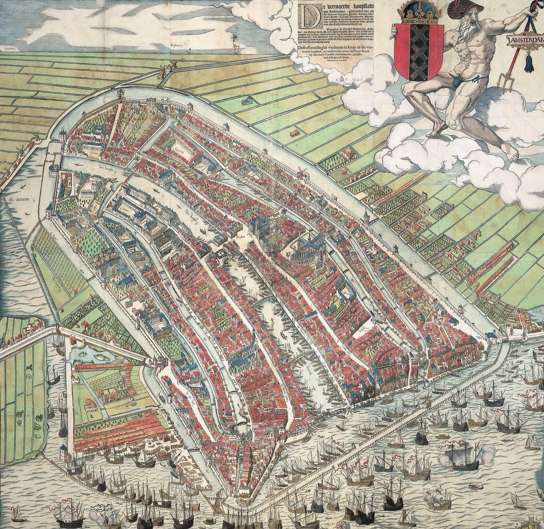
| Opis |
A bird's eye view of Amsterdam looking south. This is the city before the construction of the semi-circular ring of canals. It is bordered by the IJ, the Singel in the west, and the Kloveniersburgwal/Gelderse Kade in the east. The waterway in the middle (connecting the Dam with the IJ) is known as the Damrak. Ships were unloaded on the west bank of the Damrak, indicated on the map as ‘Opt Waeter’ (on the water). Woodcut by Cornelis Anthonisz. dated 1544. Fourth edition out of a total of six editions. This version is a reprint published by Ian Iansz. around 1557. |
||||||||||||||||||||||||||||||||||||||||||||||
| Datum | Oko 1557 | ||||||||||||||||||||||||||||||||||||||||||||||
| Medij | woodcut print, brush and color | ||||||||||||||||||||||||||||||||||||||||||||||
| Dimenzije | visina: 107 cm; Širina: 109 cm | ||||||||||||||||||||||||||||||||||||||||||||||
| Muzejska zbirka |
|
||||||||||||||||||||||||||||||||||||||||||||||
| Inventarni broj |
KOG-2684 (Royal Dutch Antiquarian Society) |
||||||||||||||||||||||||||||||||||||||||||||||
| Mjesto nastanka | Amsterdam | ||||||||||||||||||||||||||||||||||||||||||||||
| Povijest predmeta |
nepoznat datum: acquired by Koninklijk Oudheidkundig Genootschap, Inventory number KOG-2684, from jkvr. H.M.A.F. Six (?) nepoznat datum: lent to the Rijksmuseum Amsterdam, Amsterdam, by Koninklijk Oudheidkundig Genootschap (?) |
||||||||||||||||||||||||||||||||||||||||||||||
| Povijest izlaganja | Het Aanzien van Amsterdam. Panorama's, plattegronden en profielen uit de Gouden Eeuw, Stadsarchief Amsterdam, Amsterdam, 19. listopada 2007.–16. siječnja 2008., ISBN 978-90-6868-444-5, p. 90-92, kat. no. 4, with color image, as Plattegrond van Amsterdam met de gebouwen in opstand, Amsterdam, Koninklijk Oudheidkundig Genootschap. | ||||||||||||||||||||||||||||||||||||||||||||||
| Natpisi (inskripcije) |
Caption : De vermaerde koopstadt / van Amstelredam, gheconterfeyt met alle / sijn Wateren, Bruggen, Straten, kercken, kloo- / steren, Huysen, Toorens, Poorten ende Mueren, / ende omleggende situatie, gemaekt ter eeren K. M. / ende oock den Eersamen Raedt der selver Stadt, / ende alle Liefhebberen der Konste, etc. // Wtgegeven by Cornelis Anthonizoon Schil- / der, met Octroye der K. M. onsen ghenadighsten Heere van 't selfde niet te / moghen nae-drucken noch verkoopen binnen den tijdt van ses Jaren lanck / gheduerende, ende ghedateert van den Jare duysent vijf-honderd drie-en- / veertigh, op seeckere penen int selvde Octroye begrepen, op dat hem een yege- / lijck voor schade verhoede mach. // Dese afbeeldinghe vindtmen te koop in die ver- / maerde koopstadt van Amstelredam achter de Nieuwe Kerck / by den voorsz Cornelis Anthoniszoon, Schilder / inde Schrijvende handt. // ende nu by Ian Iansz, Print-drucker |
||||||||||||||||||||||||||||||||||||||||||||||
| Napomene | Van deze plattegrond zijn zes verschillende uitgaves bekend; uit 1544, 1544-1545, 1545-1553, ca. 1557, ca. 1557-1636 en 1636-1664. | ||||||||||||||||||||||||||||||||||||||||||||||
| Referencija | |||||||||||||||||||||||||||||||||||||||||||||||
| Izvor/fotograf | archive.org, cultuurwijzer.nl/nwc.gemeentearchiefamsterdam | ||||||||||||||||||||||||||||||||||||||||||||||
| Ostale inačice |
|
||||||||||||||||||||||||||||||||||||||||||||||
.jpg)


_by_Cornelis_Anthonisz.jpg)
| Annotations | This image is annotated: View the annotations at Commons |


Licencija
|
This is a faithful photographic reproduction of a two-dimensional, public domain work of art. The work of art itself is in the public domain for the following reason:
The official position taken by the Wikimedia Foundation is that "faithful reproductions of two-dimensional public domain works of art are public domain".
This photographic reproduction is therefore also considered to be in the public domain in the United States. In other jurisdictions, re-use of this content may be restricted; see Reuse of PD-Art photographs for details. | ||||
Povijest datoteke
Kliknite na datum/vrijeme kako biste vidjeli datoteku kakva je tada bila.
| Datum/Vrijeme | Minijatura | Dimenzije | Suradnik | Komentar | |
|---|---|---|---|---|---|
| sadašnja | 13:05, 11. travnja 2008. | | 2.231 × 2.171 (1,7 MB) | Vincent Steenberg | {{Information |Description={{en|Cornelis Anthonisz. ''Bird's eye view of Amsterdam.'' 1544. Woodcut.}} {{nl|Cornelis Anthonisz. ''Vogelvluchtkaart van Amsterdam.'' 1544. Houtsnede.}} |Source=http://www.cultuurwijzer.nl/nwc.gemeentearchiefamsterdam/cultuur |
Uporaba datoteke
Nijedna stranica ne rabi ovu datoteku.
Globalna uporaba datoteke
Sljedeći wikiji rabe ovu datoteku:
- Uporaba na ar.wikipedia.org
- Uporaba na en.wikipedia.org
- Uporaba na hy.wikipedia.org
- Uporaba na nl.wikipedia.org
- Uporaba na vi.wikipedia.org
- Uporaba na www.wikidata.org
- Uporaba na zh.wikipedia.org