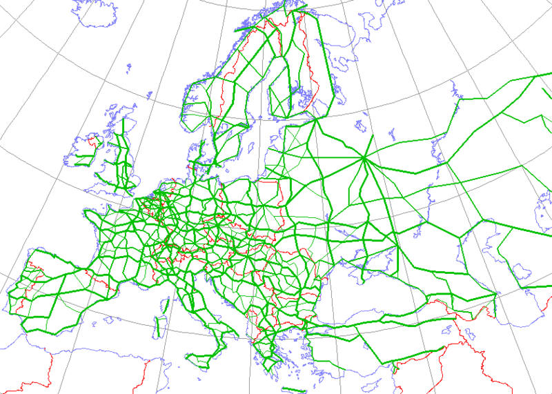
Datoteka:International E Road Network green.png

Veličina ovog prikaza: 800 × 571 piksela. Ostale razlučivosti: 320 × 229 piksela | 640 × 457 piksela.
Vidi sliku u punoj veličini (840 × 600 piksela, veličina datoteke: 38 KB, MIME tip: image/png)
Povijest datoteke
Kliknite na datum/vrijeme kako biste vidjeli datoteku kakva je tada bila.
| Datum/Vrijeme | Minijatura | Dimenzije | Suradnik | Komentar | |
|---|---|---|---|---|---|
| sadašnja | 18:09, 13. svibnja 2008. |  | 840 × 600 (38 KB) | Jklamo | Albania update |
| 14:07, 22. prosinca 2007. |  | 840 × 600 (39 KB) | BIL | == Description == {{Information |Description=Map generated using coastline/boundary data from World Data Bank, and locations from www.world-gazetteer.com. Straight lines connect control cities, no attempt to follow the real road. Roads color has been chan | |
| 22:03, 7. listopada 2007. |  | 840 × 600 (33 KB) | The RedBurn | All e-roads in green. | |
| 21:55, 7. listopada 2007. |  | 840 × 600 (34 KB) | The RedBurn | {{Information |Description=Map generated using coastline/boundary data from World Data Bank, and locations from www.world-gazetteer.com. Straight lines connect control cities, no attempt to follow the real road. Roads color has been changed to green. |Sou |
Uporaba datoteke
Na ovu sliku vode poveznice sa sljedećih stranica:
- Europska mreža međunarodnih pravaca
- Europski pravac E28
- Europski pravac E59
- Europski pravac E61
- Europski pravac E65
- Europski pravac E661
- Europski pravac E662
- Europski pravac E70
- Europski pravac E71
- Europski pravac E73
- Europski pravac E75
- Europski pravac E751
- Europski pravac E80
- Popis europskih pravaca
- Predložak:E-ceste
Globalna uporaba datoteke
Sljedeći wikiji rabe ovu datoteku:
- Uporaba na ar.wikipedia.org
- Uporaba na be.wikipedia.org
- Uporaba na bg.wikipedia.org
- Европейски път
- Европейски път Е79
- Европейски път Е70
- Европейски път Е80
- Европейски път Е67
- Европейски път Е85
- Европейски път Е851
- Европейски път Е671
- Шаблон:Европейска пътна мрежа
- Европейски път Е81
- Европейски път Е804
- Европейски път Е763
- Европейски път Е762
- Европейски път Е87
- Европейски път Е772
- Европейски път Е83
- Европейски път Е871
- Европейски път Е75
- Европейски път Е773
- Европейски път Е11
- Европейски път Е51
- Европейски път Е761
- Европейски път Е17
- Европейски път Е76
- Европейски път Е82
- Европейски път Е84
- Европейски път Е86
- Европейски път E01
- Европейски път E03
- Европейски път E04
- Европейски път E05
- Европейски път E06
- Европейски път E07
- Европейски път E08
- Европейски път E09
- Европейски път E10
- Европейски път E12
- Европейски път E13
- Европейски път E14
Pogledajte globalnu uporabu ove datoteke.
