Datoteka:Nansen Fram Map.png
Viša rezolucija nije dostupna.
Nansen_Fram_Map.png (800 × 479 piksela, veličina datoteke: 195 KB, MIME tip: image/png)
| Ova je datoteka sa Zajedničkog poslužitelja i mogu je rabiti drugi projekti. Opis s njezine stranice s opisom datoteke prikazan je ispod. |
Sažetak
| Opis |
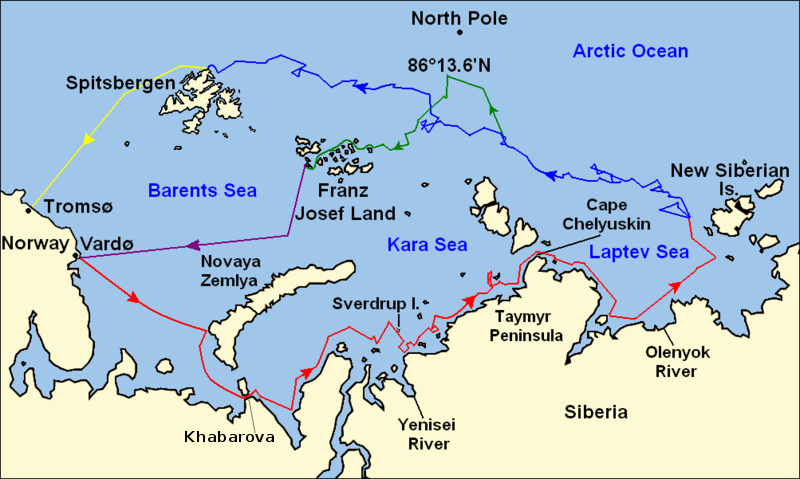
Map of the Arctic Ocean showing the routes taken during the 1893–96 Nansen's Fram expedition: Fram's route eastward from Vardø to the Siberian coast, turning north at the New Siberian Islands to enter the pack ice. July – September 1893 Fram's drift in the ice from the New Siberian Islands, north and west to Spitsbergen, September 1893 – August 1896 Nansen and Johansen's march to Farthest North, 86°20'N, and their subsequent retreat to Cape Flora in Franz Josef Land. February 1895 – June 1896 Nansen and Johansen's return to Vardø from Cape Flora, August 1896 Fram's voyage from Spitsbergen to Tromsø, August 1896 |
| Datum | |
| Izvor | Base map of European and Asian mainland is from File:Map of Russian Subjects old.png by User:fremantleboy, map of Spitsbergen (Svalbard) is based on File:Bjornoya map.png by User:NormanEinstein. Voyage traces based on this map from The Northern Lights Route. First published in Nansen, Fridtjof: Farthest North, Constable & Co, London 1897 |
| Autor | User:fremantleboy, User:NormanEinstein, Ruhrfisch |
| Dopuštenje (Naknadna uporaba ove datoteke) |
GFDL, CC-BY-SA |
| Ostale inačice |
|


|
Dostupna je vektorska inačica (SVG) ove slike. Trebala bi se koristiti umjesto ove rasterske slike ako je kvalitetnija.
File:Nansen Fram Map.png → File:Nansen Fram Map.svg
Za više informacija o vektorskoj grafici, pročitajte o prelasku Zajedničkog poslužitelja na SVG. Također pročitajte informacije o podršci MediaWiki softvera slikama u SVG formatu. |
 |
Licencija
Ja, nositelj autorskog prava za ovo djelo, ovime ga objavljujem pod sljedećim licencijama:

|
Dozvoljava se umnožavanje, dijeljenje i/ili mijenjanje ovog dokumenta pod uvjetima GNU-ove licence za slobodnu dokumentaciju, inačica 1.2 ili kasnija ako ju je objavio Free Software Foundation; bez nepromjenjivih ili obveznih dijelova i bez teksta na naslovnoj i/ili posljednjoj stranici. Kopija licencije je uključena u odjeljak naslovljen GNU-ove licence za slobodnu dokumentaciju. |
This file is licensed under the Creative Commons Attribution-Share Alike 4.0 International, 3.0 Unported, 2.5 Generic, 2.0 Generic and 1.0 Generic license.
- Slobodno smijete:
- dijeliti – umnožavati, distribuirati i javnosti priopćavati djelo
- remiksirati – prerađivati djelo
- Pod sljedećim uvjetima:
- imenovanje autora – Morate pripisati odgovarajuće autorske zasluge, dati poveznicu na licenciju, te naznačiti jesu li načinjene promjene autorskog djela. Prethodno navedeno možete učiniti na svaki razuman način, ali ne na način koji bi sugerirao da Vi ili Vaše korištenje licencorova djela ima izravno licencorovo odobrenje.
- dijeli pod istim uvjetima – Ako ovo djelo izmijenite, preoblikujete ili stvarate na osnovu tog materijala, svoje doprinose morate distribuirati pod istom ili kompatibilnom licencijom kao što je i licencija originala.
Možete odabrati licenciju prema vašem izboru.
Povijest datoteke
Kliknite na datum/vrijeme kako biste vidjeli datoteku kakva je tada bila.
| Datum/Vrijeme | Minijatura | Dimenzije | Suradnik | Komentar | |
|---|---|---|---|---|---|
| sadašnja | 14:16, 8. svibnja 2011. | | 800 × 479 (195 KB) | Chris55 | Added [http://website.lineone.net/~polar.publishing/khabarova.htm Khabarova] where they picked up the dogs. |
| 17:50, 21. listopada 2009. |  | 1.003 × 601 (78 KB) | Ruhrfisch | Make arrowheads less triangular (indentations at rear) | |
| 17:23, 21. listopada 2009. |  | 1.003 × 601 (78 KB) | Ruhrfisch | Add arrowheads per FAC | |
| 20:50, 20. listopada 2009. |  | 1.003 × 601 (78 KB) | Ruhrfisch | Make magenta line purple | |
| 15:36, 11. listopada 2009. |  | 1.003 × 601 (78 KB) | Ruhrfisch | Yellow line for orange, some labels smaller, Farthest North replaced with actual figure, all other info the same | |
| 05:08, 11. listopada 2009. |  | 1.003 × 601 (80 KB) | Ruhrfisch | Darker green for that line, all other information is the same | |
| 04:46, 11. listopada 2009. |  | 1.003 × 601 (80 KB) | Ruhrfisch | Added last two lines for ice voyages, added last labels, all other information the same. | |
| 21:30, 9. listopada 2009. |  | 1.003 × 601 (73 KB) | Ruhrfisch | Add labels, two more voyage lines, all other information is the same | |
| 18:12, 9. listopada 2009. |  | 1.003 × 601 (57 KB) | Ruhrfisch | == Summary == {{Information |Description = Map of the Arctic Ocean showing the path of Nansen's Fram expedition 1893 to 1896 |Source = Base map of European mainland is from [[:File:Map of Russian Subjects old.png] |
Uporaba datoteke
Na ovu sliku vode poveznice sa sljedećih stranica:
Globalna uporaba datoteke
Sljedeći wikiji rabe ovu datoteku:
- Uporaba na bg.wikipedia.org
- Uporaba na en.wikipedia.org
- Uporaba na es.wikipedia.org
- Uporaba na fr.wikipedia.org
- Uporaba na id.wikipedia.org
- Uporaba na ja.wikipedia.org
- Uporaba na pt.wikipedia.org
- Uporaba na sl.wikipedia.org