Datoteka:Western Front 1917.jpg
Veličina ovog prikaza: 775 × 600 piksela. Ostale razlučivosti: 310 × 240 piksela | 620 × 480 piksela | 993 × 768 piksela | 1.242 × 961 piksela.
Vidi sliku u punoj veličini (1.242 × 961 piksela, veličina datoteke: 228 KB, MIME tip: image/jpeg)
| Ova je datoteka sa Zajedničkog poslužitelja i mogu je rabiti drugi projekti. Opis s njezine stranice s opisom datoteke prikazan je ispod. |
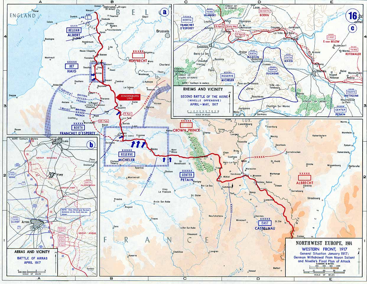
| Opis | Map of the Western Front, 1917. The red line marks the front as of 5 April 1917. The Siegfriedstellung or Hindenburg Line, only ran from Arras to Laffaux (shown in insert) on the river Aisne - essentially the portion to the east of the dotted red line marking the 25 February front. | |||
| Datum | ||||
| Izvor | Campaign Atlas to the Great War (specifically 16. Western Front, 1917, The Battle of Arras and the Second Battle of the Aisne) | |||
| Autor | United States Military Academy’s Department of History[1] | |||
| Dopuštenje (Naknadna uporaba ove datoteke) |
|
|||
| Ostale inačice | Radovi izvedeni od ove datoteke: USMA - Battle of Arras - Vimy Ridge derivative.png |

This file was reviewed on 1 June 2009 by the administrator or trusted user Jappalang (talk), who confirmed the Public Domain status on that date.
|
Transfer history
First uploaded in English Wikipedia as en:Image:Western_Front_1917.jpg by en:User:Ghepeu (10:53, 13 January 2006 . . Ghepeu (Talk) . . 1242x961 (233585 bytes))
Povijest datoteke
Kliknite na datum/vrijeme kako biste vidjeli datoteku kakva je tada bila.
| Datum/Vrijeme | Minijatura | Dimenzije | Suradnik | Komentar | |
|---|---|---|---|---|---|
| sadašnja | 12:11, 2. svibnja 2006. | | 1.242 × 961 (228 KB) | Ideru~commonswiki | == Original Comments == Map of the Western Front (World War I), 1917 From the History Department of the US Military Academy West Point - [http://www.dean.usma.edu/history/web03/atlases/great%20war/great%20war%20index.htm] First uploaded in Engli |
Uporaba datoteke
Na ovu sliku vode poveznice sa sljedećih stranica:
Globalna uporaba datoteke
Sljedeći wikiji rabe ovu datoteku:
- Uporaba na ar.wikipedia.org
- Uporaba na be-tarask.wikipedia.org
- Uporaba na be.wikipedia.org
- Uporaba na bn.wikipedia.org
- Uporaba na cs.wikipedia.org
- Uporaba na da.wikipedia.org
- Uporaba na de.wikipedia.org
- Uporaba na el.wikipedia.org
- Uporaba na en.wikipedia.org
- Western Front (World War I)
- Schneider CA1
- Second Battle of the Aisne
- Nivelle offensive
- Battle of Drocourt-Quéant Line
- Operation Alberich
- Western Front tactics, 1917
- User:Stephen2nd/German deployments in WWI
- Army Group East (France)
- Army Group Centre (France)
- Army Group North (France)
- Army Group Reserve (France)
- Uporaba na es.wikipedia.org
- Uporaba na eu.wikipedia.org
- Uporaba na fa.wikipedia.org
- Uporaba na fi.wikipedia.org
- Uporaba na fr.wikipedia.org
- Uporaba na he.wikipedia.org
- Uporaba na hu.wikipedia.org
- Uporaba na ja.wikipedia.org
- Uporaba na ka.wikipedia.org
- Uporaba na ko.wikipedia.org
- Uporaba na lv.wikipedia.org
- Uporaba na no.wikipedia.org
- Uporaba na pl.wikipedia.org
- Uporaba na pt.wikipedia.org
- Uporaba na ro.wikipedia.org
Pogledajte globalnu uporabu ove datoteke.