Derinkuyu
Derinkuyu (turski za duboki bunar) grad je i okrug u Nevşehiru, turskoj pokrajini u središnjoj Anatoliji. Za popisa stanovništva 2010. godine okrug je imao 22 114 stanovnika od kojih je 10 679 živjelo u gradu Derinkuyu. Okrug se prostire na površini od 445 km2[1] na prosječnoj nadmorskoj visini od 1300 m. Najviša planina je Ertaş s vrhom na 1988 mnm.
| Nacionalni park Göreme i lokaliteti u stijenama Kapadocije | |
|---|---|
 Tuneli podzemnog grada Derinkuyua | |
| Država | |
| Godina uvrštenja | 1985. (9. zasjedanje) |
| Vrsta | Kulturno dobro |
| Mjerilo | i, iii, v, vii |
| Ugroženost | — |
| Poveznica | UNESCO:357 |
| Koordinate | 38°22′25″N 34°44′05″E / 38.37361°N 34.73472°E |
 Derinkuyu Položaj Derinkuyua u Turskoj | |
Derinkuyu je poznat po velikom podzemnom gradu na više razina, koji je značajna turska turistička atrakcija. Povijesna regija Kapadocija u kojoj se nalazio Derinkuyu imala je nekoliko, sada uglavnom napuštenih podzemnih gradova isklesanih u jedinstvenoj geološkoj formaciji. Više od 200 podzemnih gradova dubokih najmanje dvije razine otkriveno je u području između Kayserija i Nevşehira; njih četrdesetak ima barem tri razine. Trogloditski gradovi Derinkuyu i Kaymaklı, povezani osamkilometarskim tunelom,[2] najbolji su primjeri stanovanja pod zemljom.
Povijest uredi
Najstariji pisani izvor o podzemnim građevinama Ksenofontov je spis Anabaza. On piše da su ljudi koji su živjeli u Anatoliji iskopali svoje kuće pod zemljom, živeći dobro u nastambama dovoljno velikim za obitelj, domaće životinje i zalihe hrane.[3]
Smatra se da su špilje u mekanim vulkanskim stijenama prvobitno izgradili Frigijci u 8. ili 7. stoljeću pr. n. e.[4] Kada je u rimsko doba frigijski jezik izumro i bio zamijenjen grčkim jezikom,[5] stanovnici su, sada kršćani, proširili svoje špilje na duboke strukture na više razina dodajući kapele i natpise na grčkom.[6]
Od bizantskih vremena u 4. stoljeću pa do napuštanja grada 1923. godine Derinkuyu je među svojim stanovnicima, kapadocijskim Grcima, bio poznat kao Malakopea (grčki: Μαλακοπέα).[7] Podzemni grad uvelike je proširen sredinom bizantskog razdoblja kako bi služio kao utočište za napada armija umajadskih Arapa i Abasida, tijekom arapsko-bizantskih ratova (od 780. do 1180. godine).[8][9]

Podzemni grad Derinkuyu ima najmanje osam razina i dubinu od 85 m, a mogao je pružiti utočište tisućama ljudi. Svaki kat mogao se iznutra zatvoriti velikim kružnim kamenim vratima. Grad je imao prodavaonice hrane, kuhinje, štandove, crkve, preše za vino i ulje, ventilacijske otvore, bunare i vjersku školu, vjerojatno u velikoj dvorani s bačvastim svodom.[10] Grad se koristio kao zaštita od mongolskih upada u Timur u 14. stoljeću.[11][12]
Nakon što je regija pala pod Osmanlije gradovi su korišteni kao skloništa (grčki: καταφύγια). Sve do dvadesetog stoljeća stanovnici grada koristili su podzemne odaje kako bi pobjegli od povremenih otomanskih progona. Jezikoslovac s Cambridgea R. Dawkins, koji je boravio u gradovima 1910. i 1911. godine dok je pisao svoju knjigu o kapadokijskom grčkom jeziku, naveo je: »Njihovo korištenje kao utočišta za vrijeme opasnosti naznačeno je njihovim imenom καταφύγια. Kada su 1909. stigle vijesti o masakrima u Adani velik dio stanovništva našao je utočište u ovim podzemnim odajama i nekoliko noći nisu se usuđivali spavati iznad zemlje.«[13]
Tuneli su konačno napušteni kada su Grci u razmjeni stanovništva između Grčke i Turske 1923. godine morali napustiti Kapadociju.[9][14]
Tuneli su ponovno otkriveni 1963. godine kada je stanovnik Derinkuyua pri renoviranju kuće iza zida pronašao skrivenu sobu. Daljnjim kopanjem otkriven je pristup mreži tunela.[15] Nalazište je za posjetitelje otvoreno 1969. godine,[16] a sada im je dostupan manji dio podzemnog grada.[10]
Slike podzemnog grada uredi
-
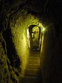 Stubište u podzemnom gradu
 -
 Vrata u podzemnom gradu
 -
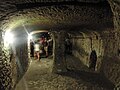 Odaja u podzemnom gradu
 -
 Velika soba u blizini posljednjeg izlaza


Izvori uredi
- ↑ Statoids. Statistical information on districts of Turkey. Pristupljeno 14. travnja 2008.
- ↑ Martin, Anthony J. 7. veljače 2017. The Evolution Underground (engleski). Simon and Schuster. ISBN 978-1-68177-375-9
- ↑ Ksenofont. Anabaza. 4.5.24-7
- ↑ Nevsehir. Ministarstvo kulture Turske. Inačica izvorne stranice arhivirana 18. veljače 2020. Pristupljeno 9. siječnja 2023.
- ↑ Swain, Simon; Adams, J. Maxwell; Janse, Mark. 2002. Bilingualism in Ancient Society: Language Contact and the Written Word. Oxford University Press. Oxford. str. 246–266. ISBN 0-19-924506-1
- ↑ Darke, Diana. 2011. Eastern Turkey. Bradt Travel Guides. str. 139–140. ISBN 978-1-84162-339-9.
The area became an important frontier province during the 7th century when Arab raids on the Byzantine Empire began. By now the soft tufa had been tunneled and chambered to provide underground cities where a settled if cautious life could continue during difficult times. When the Byzantines re-established secure control between the 7th and 11th centuries, the troglodyte population surfaced, now carving their churches into rock faces and cliffs in the Goreme and Soganli areas, giving Cappadocia its fame today. […] At any rate here they flourished, their churches remarkable for being cut into the rock, but interesting especially for their paintings, relatively well preserved, rich in coloring, and with an emotional intensity lacking in the formalism of Constantinople; this is one of the few places where paintings from the pre-iconoclastic period have survived. Icons continued to be painted after the Seljuk conquest of the area in the 11th century, and the Ottoman conquest did not interfere with the Christian practices in Cappadocia, where the countryside remained largely Greek, with some Armenians. But decline set in and Goreme, Ihlara and Soganli lost their early importance. The Greeks finally ending their long history here with the mass exchange of populations between Turkey and Greece in 1923.
- ↑ Peter Mackridge, "Some Pamphlets on Dead Greek Dialects': R.M. Dawkins and Modern Greek Dialectology", 1990. p. 205.
- ↑ Horrocks, Geoffrey C. 2010. Greek: A History of the Language and Its Speakers. John Wiley & Sons. str. 403. ISBN 978-1-4051-3415-6.
None the less, at the beginning of the 20th century, Greek still had a strong presence in Silli north-west of Konya (ancient Ikonion), in Pharasa and other villages in the region drained by the Yenice river (some 100 km south of Kayseri, ancient Caesarea), and in Cappadocia proper, at Arabison (Arapsu/Gulsehir) north-west of Nevşehir (ancient Nyssa), and in the large region south of Nevşehir as far down as Nigde and Bor (close to ancient Tyana). This whole area, as the home of St Basil the Great (329–79), his brother St Gregory of Nyssa (335–94) and his friend St Gregory of Nazianzos (330–89), was of great importance in the early history of Christianity, but is perhaps most famous today for the extraordinary landscape of eroded volcanic tufa in the valleys of Goreme, Ihlara and Soganh, and for the churches and houses carved into the ‘fairy chimneys’ to serve the Christian population in the middle ages. Many of the rock cut churches, which range in date from the 6th to the 13th centuries, contain magnificent frescos. Away from the valleys, some of the villages have vast underground complexes containing houses, cellars, stables, refectories, cemeteries and churches, affording protection from marauding Arabs in the days when the Byzantine empire extended to the Euphrates, and serving later as places of refuge from hostile Turkish raiders. The most famous of these are at Kaymakli and Derinkuyu, formerly the Greek villages of Anaku (Inegi) and Malakopi (Melagob), where the chambers extended down over several levels of depths of up to 85 metres.
- ↑ a b Darke, Diana. 2011. Eastern Turkey. Bradt Travel Guides. str. 139–140. ISBN 978-1-84162-339-9.
The area became an important frontier province during the 7th century when Arab raids on the Byzantine Empire began. By now the soft tufa had been tunneled and chambered to provide underground cities where a settled if cautious life could continue during difficult times. When the Byzantines re-established secure control between the 7th and 11th centuries, the troglodyte population surfaced, now carving their churches into rock faces and cliffs in the Goreme and Sogamli areas, giving Cappadocia its fame today. […] At any rate here they flourished, their churches remarkable for being cut into the rock, but interesting especially for their paintings, relatively well preserved, rich in coloring, and with an emotional intensity lacking in the formalism of Constantinople; this is one of the few places where paintings from the pre-iconoclastic period have survived. Icons continued to be painted after the Seljuk conquest of the area in the 11th century, and the Ottoman conquest did not interfere with the Christian practices in Cappadocia, where the countryside remained largely Greek, with some Armenians. But decline set in and Goreme, Ihlara and Soganli lost their early importance. The Greeks finally ending their long history here with the mass exchange of populations between Turkey and Greece in 1923.
- ↑ a b Derinkuyu Underground City. Nevşehir Province. Inačica izvorne stranice arhivirana 9. siječnja 2007.
- ↑ Kinross, Baron Patrick Balfour. 1970. Within the Taurus: a journey in Asiatic Turkey. J. Murray. str. 168. ISBN 978-0-7195-2038-9.
Its inhabitants were Cappadocian Greeks, who may have found a refuge here, perhaps from Roman, from Iconoclast, or later from Turkish and Mongol threats. Urgup itself was the Byzantine Prokopion; the Emperor Nicephoros Phocas is said to have passed this way, after his Cilician campaign; and the neighborhood was populous enough to support, at different times, a number of bishoprics.
- ↑ Dawkins, R.M. 1916. Modern Greek in Asia Minor. A study of dialect of Silly, Cappadocia and Pharasa. Cambridge University Press. str. 17. Pristupljeno 25. listopada 2014..
these excavations are referred to as long ago as the campaigns of Timour Beg, one of whose captains was sent to hunt out the inhabitants of Kaisariyeh, who had taken refuge in their underground dwellings, and was killed by an arrow shot through the hole in one of the doors.
- ↑ Dawkins, R.M. 1916. Modern Greek in Asia Minor. A study of dialect of Silly, Cappadocia and Pharasa. Cambridge University Press. str. 16. Pristupljeno 25. listopada 2014..
their use as places of refuge in time of danger is indicated by their name καταφύγια, and when the news came of the recent massacres at Adana [in 1909], a great part of the population at Axo took refuge in these underground chambers, and for some nights did not venture to sleep above ground.
- ↑ Rodley, Lyn. 2010. Cave Monasteries of Byzantine Cappadocia. Cambridge University Press. str. 1. ISBN 978-0-521-15477-2.
The tenth-century historian Leo the Deacon records a journey to Cappadocia made by Nikephoros Phokas shortly before he became emperor. Perhaps to recapture the attention of readers beginning to tire of troop movements he also offers a scrap of information about a curiosity of the region to which the emperor was heading: its inhabitants were once called troglodytes, because ‘they went underground in holes, clefts and labyrinths, as it were in dens and burrows’. This brief note was probably not based on first-hand knowledge but it might have been prompted by an awareness of the vast number of rock-cut cavities in an area to the west and southwest of Kaisareia (Kayseri of modern Turkey). Had Leo been more inclined to garrulous digression (or perhaps just better informed), he might have supplied more details of the troglodyte region and the task of bringing scholarly order to the hundreds of rock-cut monuments and other cavities in the area might have been much similar. … At this time the region was still inhabited by a mixed population of Turkish-speaking Moslems and Greek-speaking Christians. The latter group left for Greece in the early 1920s, during an exchange of population of minorities that was part of the radical social re-ordering initiated by Kemal Atatürk; they were replaced by Turks from Greece, mostly from Thrace. In the two decades before this upheaval, however, members of the local Greek population acted as guides to Guillaume de Jerphanion, who made several visits to the volcanic valleys and wrote his meticulous descriptions of many painted Byzantine rock-cut churches.
- ↑ History.com. 14. prosinca 2016. 8 Mysterious Underground Cities. History.com
- ↑ Nývlt, Vladimír; Musílek, Josef; Čejka, Jiří; Stopka, Ondrej. 1. siječnja 2016. The Study of Derinkuyu Underground City in Cappadocia Located in Pyroclastic Rock Materials. Procedia Engineering. World Multidisciplinary Civil Engineering-Architecture-Urban Planning Symposium 2016, WMCAUS 2016 (engleski). 161: 2253–2258. doi:10.1016/j.proeng.2016.08.824. ISSN 1877-7058
Vanjske poveznice uredi
- Službena stranica guvernera okruga (turski)
- Službena stranica općine okruga (turski)
- Opće informacije o Derinkuyuu. derinkuyu.gov.tr (turski). Inačica izvorne stranice arhivirana 30. lipnja 2008. Pristupljeno 14. travnja 2008.