Datoteka:Europe 912.jpg
Veličina ovog prikaza: 584 × 599 piksela. Ostale razlučivosti: 234 × 240 piksela | 468 × 480 piksela | 998 × 1.024 piksela.
Vidi sliku u punoj veličini (998 × 1.024 piksela, veličina datoteke: 414 KB, MIME tip: image/jpeg)
| Ova je datoteka sa Zajedničkog poslužitelja i mogu je rabiti drugi projekti. Opis s njezine stranice s opisom datoteke prikazan je ispod. |
Sažetak
| Opis |
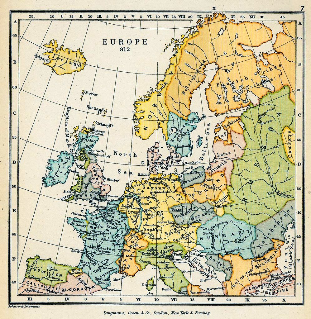
English: Map of Europe in 912 CE. |
| Datum | |
| Izvor |
|
| Autor | Charles Colbeck |
Licencija
This media file is in the public domain in the United States. This applies to U.S. works where the copyright has expired, often because its first publication occurred prior to January 1, 1929, and if not then due to lack of notice or renewal. See this page for further explanation.
|
 | |
 |
This image might not be in the public domain outside of the United States; this especially applies in the countries and areas that do not apply the rule of the shorter term for US works, such as Canada, Mainland China (not Hong Kong or Macao), Germany, Mexico, and Switzerland. The creator and year of publication are essential information and must be provided. See Wikipedia:Public domain and Wikipedia:Copyrights for more details.
|
Povijest datoteke
Kliknite na datum/vrijeme kako biste vidjeli datoteku kakva je tada bila.
| Datum/Vrijeme | Minijatura | Dimenzije | Suradnik | Komentar | |
|---|---|---|---|---|---|
| sadašnja | 20:16, 18. lipnja 2009. | | 998 × 1.024 (414 KB) | Yarl | corrected |
| 01:31, 14. studenoga 2007. |  | 998 × 1.024 (405 KB) | Pudeo~commonswiki | {{Information |Description=The Public Schools Historical Atlas" by Charles Colbeck. Longmans, Green; New York; London; Bombay. 1905. Users can access the index to locate place names within the atlas. |Source=[http://www.lib.utexas.edu/maps/historical/hist |
Uporaba datoteke
Na ovu sliku vode poveznice sa sljedećih stranica:
Globalna uporaba datoteke
Sljedeći wikiji rabe ovu datoteku:
- Uporaba na de.wikipedia.org
- Uporaba na ru.wikipedia.org
- Uporaba na sh.wikipedia.org
- Uporaba na sr.wikipedia.org
- Uporaba na uk.wikipedia.org