Datoteka:IslamicConquestsIroon.png
Veličina ovog prikaza: 675 × 599 piksela. Ostale razlučivosti: 270 × 240 piksela | 541 × 480 piksela | 1.006 × 893 piksela.
Vidi sliku u punoj veličini (1.006 × 893 piksela, veličina datoteke: 105 KB, MIME tip: image/png)
| Ova je datoteka sa Zajedničkog poslužitelja i mogu je rabiti drugi projekti. Opis s njezine stranice s opisom datoteke prikazan je ispod. |

|
This historical map image could be re-created using vector graphics as an SVG file. This has several advantages; see Commons:Media for cleanup for more information. If an SVG form of this image is available, please upload it and afterwards replace this template with
{{vector version available|new image name}}.
It is recommended to name the SVG file “IslamicConquestsIroon.svg”—then the template Vector version available (or Vva) does not need the new image name parameter. |
| Opis |
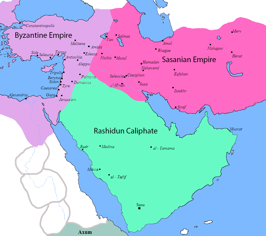
English: Map of the Sassanid, Byzantine and Muslim borders. |
| Izvor | File:Pre_Islamic_Arabia.PNG |
| Autor | Javierfv1212 and edited by HistoryofIran. |
| Ostale inačice |
[]
|


This file is in the public domain because File:Pre_Islamic_Arabia.PNG
|
Povijest datoteke
Kliknite na datum/vrijeme kako biste vidjeli datoteku kakva je tada bila.
| Datum/Vrijeme | Minijatura | Dimenzije | Suradnik | Komentar | |
|---|---|---|---|---|---|
| sadašnja | 12:13, 18. rujna 2019. | | 1.006 × 893 (105 KB) | HistoryofIran | rv, thats not how it works |
| 06:51, 18. rujna 2019. |  | 1.006 × 893 (103 KB) | Сахалин21 | Under Hormizd IV, Persia won the Perso-Turkic War and conquered Samarqand and the Transoxiania. | |
| 06:50, 18. rujna 2019. |  | 1.006 × 893 (105 KB) | Сахалин21 | Reverted to version as of 01:15, 3 August 2019 (UTC) | |
| 06:45, 18. rujna 2019. |  | 1.006 × 893 (103 KB) | Сахалин21 | Reverted to version as of 19:13, 14 November 2017 (UTC) | |
| 03:15, 3. kolovoza 2019. |  | 1.006 × 893 (105 KB) | HistoryofIran | rv, no, they weren't at all | |
| 20:38, 1. kolovoza 2019. |  | 1.006 × 893 (105 KB) | Mehrdad 12 | The eastern borders were conquered during the reign of Queen Purandokht. | |
| 20:34, 1. kolovoza 2019. |  | 1.006 × 893 (106 KB) | Mehrdad 12 | I corrected the eastern borders. The Great Khorasan and Khwarizmi Desert were considered imperial. | |
| 04:51, 12. veljače 2019. |  | 1.006 × 893 (105 KB) | HistoryofIran | Made the map somewhat more accurate, probably more to come. | |
| 21:13, 14. studenoga 2017. |  | 1.006 × 893 (103 KB) | HistoryofIran | rv, the Sasanian Empire didnt control that much | |
| 13:02, 12. studenoga 2017. |  | 1.006 × 893 (128 KB) | Mehrdad 12 | {{NAMESPACE}}{{PAGENAME}}[[]][[:File:]]]] |
Uporaba datoteke
Na ovu sliku vode poveznice sa sljedećih stranica:
Globalna uporaba datoteke
Sljedeći wikiji rabe ovu datoteku:
- Uporaba na bg.wikipedia.org
- Uporaba na bn.wikipedia.org
- Uporaba na bn.wikiquote.org
- Uporaba na bs.wikipedia.org
- Uporaba na cs.wikipedia.org
- Uporaba na da.wikipedia.org
- Uporaba na de.wikipedia.org
- Uporaba na diq.wikipedia.org
- Uporaba na en.wikipedia.org
- Uporaba na fa.wikipedia.org
- Uporaba na fa.wikibooks.org
- Uporaba na fi.wikipedia.org
- Uporaba na fr.wikipedia.org
- Uporaba na he.wikipedia.org
- Uporaba na hy.wikipedia.org
- Uporaba na hyw.wikipedia.org
- Uporaba na ka.wikipedia.org
- Uporaba na ko.wikipedia.org
- Uporaba na ru.wikipedia.org
- Uporaba na sr.wikipedia.org
- Uporaba na sv.wikipedia.org
- Uporaba na ta.wikipedia.org
- Uporaba na th.wikipedia.org
- Uporaba na tr.wikipedia.org
- Uporaba na uk.wikipedia.org
- Uporaba na uz.wikipedia.org
- Uporaba na zh.wikipedia.org