Datoteka:The swimming pool area of the former Ducor Palace Hotel in Monrovia, Liberia.jpg

Vidi sliku u punoj veličini (4.041 × 2.684 piksela, veličina datoteke: 4,77 MB, MIME tip: image/jpeg)
| Ova je datoteka sa Zajedničkog poslužitelja i mogu je rabiti drugi projekti. Opis s njezine stranice s opisom datoteke prikazan je ispod. |
Sažetak
| Opis |
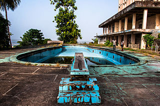
English: The swimming pool area of the former Ducor Palace Hotel in Monrovia, Liberia.
The Ducor Palace Hotel in Monrovia was the first international-class hotel constructed in Liberia, and was for many years one of the few five-star hotels in all of Africa. It had three hundred rooms, a pool, tennis courts, and a French restaurant and was popular with tourists and businesspeople from Africa and around the world. It sits on Ducor Hill and overlooks the Atlantic Ocean and the Saint Paul River. The hotel closed in 1989, just before the First Liberian Civil War. The building was severely damaged by the violence of the war and the looting that occurred afterwards. During and after the war, displaced residents of many of Monrovia's slums began to occupy the hotel's empty rooms. In 2007, the Liberian Ministry of Justice began to evict the Ducor Hotel's residents and in 2008, the Government of Liberia signed a lease agreement with the Government of Libya, who began clearing the property of debris in 2010 in preparation for a bidding process to be completed by June 2010. The project was delayed several times before finally being abandoned upon Liberia's severing of diplomatic relations with the Gaddafi government following the outbreak of the 2011 Libyan civil war. The building is open today and visitors can walk throughout the grounds and building (often after paying a "security fee" to have one of the guards accompany them). It is a popular place for Monrovia residents to come and enjoy the panoramic view of the city, especially for special occasions like Christmas, New Years, and Independence Day. |
| Datum | |
| Izvor | https://www.flickr.com/photos/fischerfotos/13045364134/ |
| Autor | Mark Fischer |
| Lokacija kamere | | Ova i druge slike na njihovim lokacijama na: OpenStreetMap |
|---|
Licencija
| This image was originally posted to Flickr. Its license was verified as "cc-by-sa-2.0" by the UploadWizard Extension at the time it was transferred to Commons. See the license information for further details. |
- Slobodno smijete:
- dijeliti – umnožavati, distribuirati i javnosti priopćavati djelo
- remiksirati – prerađivati djelo
- Pod sljedećim uvjetima:
- imenovanje autora – Morate pripisati odgovarajuće autorske zasluge, dati poveznicu na licenciju, te naznačiti jesu li načinjene promjene autorskog djela. Prethodno navedeno možete učiniti na svaki razuman način, ali ne na način koji bi sugerirao da Vi ili Vaše korištenje licencorova djela ima izravno licencorovo odobrenje.
- dijeli pod istim uvjetima – Ako ovo djelo izmijenite, preoblikujete ili stvarate na osnovu tog materijala, svoje doprinose morate distribuirati pod istom ili kompatibilnom licencijom kao što je i licencija originala.
Povijest datoteke
Kliknite na datum/vrijeme kako biste vidjeli datoteku kakva je tada bila.
| Datum/Vrijeme | Minijatura | Dimenzije | Suradnik | Komentar | |
|---|---|---|---|---|---|
| sadašnja | 01:41, 10. kolovoza 2015. | | 4.041 × 2.684 (4,77 MB) | Alifazal | User created page with UploadWizard |
Uporaba datoteke
Na ovu sliku vode poveznice sa sljedećih stranica:
Globalna uporaba datoteke
Sljedeći wikiji rabe ovu datoteku:
- Uporaba na de.wikipedia.org
- Uporaba na en.wikipedia.org
- Uporaba na en.wikivoyage.org
- Uporaba na www.wikidata.org